
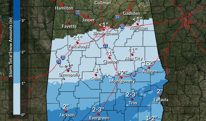
For the second time this month, Gov. Kay Ivey issued a state of emergency ahead of expected dangerous winter weather. Now, it’s central and southern counties bracing for snow and ice.
“Alabama, once again, is faced with the potential for winter weather, but this time, for the southern half of the state,” Ivey said in a written statement Monday. “We are anticipating potentially dangerous and uncertain driving conditions in the impacted portions of the state, so I am urging Alabamians to err on the side of caution and limit their travel. Make any necessary preparations now, stay tuned in to your weather forecasts and stay warm.”
The counties under a state emergency starting at 5 p.m. Monday are: Autauga, Baldwin, Barbour, Bibb, Bullock, Butler, Chambers, Chilton, Choctaw, Clarke, Coffee, Conecuh, Coosa, Covington, Crenshaw, Dale, Dallas, Elmore, Escambia, Geneva, Greene, Hale, Henry, Houston, Lee, Lowndes, Macon, Marengo, Mobile, Monroe, Montgomery, Perry, Pike, Randolph, Russell, Sumter, Tallapoosa, Washington and Wilcox.
Timing Tuesday: Most of the activity will move southwest to northeast, moving over the same areas, which is why the time listed is long for each area. Impacts will continue well beyond the end times in each area, as temperatures drop below freezing in the evening. pic.twitter.com/hFlMRmQNHN
— NWS Birmingham (@NWSBirmingham) January 20, 2025
The National Weather Service has issued winter storm watches and warnings for central and south Alabama from 6 a.m. Tuesday to 6 a.m. Wednesday. Accumulating snowfall is expected generally south of Interstate 20, according to the NWS.
“Tuesday night, we will see temperatures in the teens across most of the state and maybe into the single digits in the northern part,” said NWS Meteorologist Hunter Robinson, speaking with Alabama Daily News Monday.
“We expect snowfall to come in starting (Tuesday) probably around late morning. Most of the snowfall is going to stay south of the U.S. 80/Interstate 85 corridor. Currently we expect for the greatest snow totals to be from Mobile to northeastward toward the Troy area.”
Robinson said that Birmingham would likely see only a quarter to half an inch of snow Tuesday, Montgomery, Auburn and Selma, potentially a half an inch to an inch and a half, and Mobile up to Crenshaw County, as much as three inches, something Robinson said was very unusual.
“I do know that the Weather Service in Mobile mentioned that it’s only happened a handful of times since the 1800s, that (Mobile) has had this much potential snow,” he said.
Multiple state agencies are warning people to use caution, and stay home if possible as one to three inches of snow is possible.
Roads, and especially bridges and overpasses, will likely become slick and hazardous, the National Weather Service warns.
“Plan on slippery road conditions,” it says. “The hazardous conditions could impact the Tuesday morning and evening commutes.”
In a Sunday press release, the Alabama Law Enforcement Agency said unnecessary travel should be avoided.
“We recognize that winter weather can pose unique challenges for our Alabama communities, particularly in those areas where snow and ice are rare,” ALEA Secretary Hal Taylor said. “Our primary goal is to keep our citizens safe. Reducing unnecessary travel during dangerous conditions is crucial to preventing accidents and ensuring first responders can perform their duties efficiently.”
The Alabama Department of Transportation on Saturday said it was preparing for snow and ice, with heavier snowfall expected south of Interstate 20.
“(The department) is planning extensive pretreatment operations across the state and will conduct active clearing and treatment operations when snowfall begins,” a news release said. “Even with treatment and response efforts, road conditions in some areas may become challenging.”
Some closures have already been announced. Coastal Alabama Community College campuses and Auburn University at Montgomery will not have classes on Tuesday or Wednesday, the schools said.