Forecasters are warning of a “historic” winter storm affecting southern Alabama today, with several inches of snow possible in southern counties.
Central and southern counties, from Mobile to Montgomery, were under a winter storm warning that started at 6 a.m. today, according to the National Weather Service.
“This has the potential to be an HISTORIC winter storm for the southern half of the area,” the National Weather Service’s Mobile and Pensacola office said Monday afternoon.
North of Montgomery, several counties were under a winter weather advisory this morning while much of the state from Tuscaloosa to Birmingham and north was under a cold weather advisory.
The NWS in Birmingham warned this morning that driving is expected to become dangerous or impossible along the I-85 corridor through the day, with lesser impacts to the north up to the I-20 corridor.
8:40p 1/20: Winter weather is expected on Tuesday, with continued cold temperatures and dangerously cold wind chills through Wednesday morning. Details: #alwx pic.twitter.com/X9WIsNBszR
— NWS Birmingham (@NWSBirmingham) January 21, 2025
For the second time this month, Gov. Kay Ivey issued a state of emergency ahead of expected dangerous winter weather.
“Alabama, once again, is faced with the potential for winter weather, but this time, for the southern half of the state,” Ivey said in a written statement Monday. “We are anticipating potentially dangerous and uncertain driving conditions in the impacted portions of the state, so I am urging Alabamians to err on the side of caution and limit their travel. Make any necessary preparations now, stay tuned in to your weather forecasts and stay warm.”
The counties under a state emergency starting at 5 p.m. Monday are: Autauga, Baldwin, Barbour, Bibb, Bullock, Butler, Chambers, Chilton, Choctaw, Clarke, Coffee, Conecuh, Coosa, Covington, Crenshaw, Dale, Dallas, Elmore, Escambia, Geneva, Greene, Hale, Henry, Houston, Lee, Lowndes, Macon, Marengo, Mobile, Monroe, Montgomery, Perry, Pike, Randolph, Russell, Sumter, Tallapoosa, Washington and Wilcox.
“Tuesday night, we will see temperatures in the teens across most of the state and maybe into the single digits in the northern part,” said NWS Meteorologist Hunter Robinson, speaking with Alabama Daily News Monday.
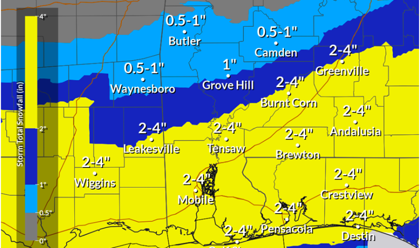
“We expect snowfall to come in starting (Tuesday) probably around late morning. Most of the snowfall is going to stay south of the U.S. 80/Interstate 85 corridor. Currently we expect for the greatest snow totals to be from Mobile to northeastward toward the Troy area.”
Robinson said that Birmingham would likely see only a quarter to half an inch of snow Tuesday, Montgomery, Auburn and Selma, potentially a half an inch to an inch and a half, and Mobile up to Crenshaw County, as much as three inches, something Robinson said was very unusual.
“I do know that the Weather Service in Mobile mentioned that it’s only happened a handful of times since the 1800s, that (Mobile) has had this much potential snow,” he said.
Multiple state agencies are warning people to use caution, and stay home if possible as one to three inches of snow is possible.
The massive winter storm brought cold and winter conditions to much of the country Monday. Around 40 million people, primarily across the southern U.S., were under some type of weather hazard, including more than 21 million under a winter storm warning, The Associated Press reported. About 170 million people from the Rockies to points eastward were under either an extreme warning or a cold weather advisory.